A country's water resources depend on its position in relation to the ocean, the characteristics of its land mass, and its position relative to the general global circulation of the atmosphere. In each hemisphere belts of cyclones and anticyclones form similar patterns rising low pressure air near the Equator and round the Poles, with descending high pressure air in the middle latitudes between the two low pressure regions. The positions of these belts vary with the seasons, all shifting northwards in the Australian winter and southwards in its summer.
 New South Wales lies in the middle latitudes, between 28° and 37° South, and so the Southern Hemisphere anticyclone belt exerts the major influence on its weather. Travelling from west to east around the globe, the separate high pressure cells of this belt normally pass on the northern side of the State in winter (permitting the southern depressions to make some penetration) and on its southern side in summer.
Australia's average annual rainfall of about 18 inches is about three quarters of that received in the other inhabited continents, except South America which receives three times Australia's average. Lying as it does in the middle latitudes, a large part of the Australian continent comes under the influence of the sub tropical high pressure systems, which form a belt of dry, descending air. There are two of these belts, one in each hemisphere. The land which they cover is predominantly deficient in rainfall and includes the world's great deserts. Moreover, unlike some of the other countries within the influence of the high pressure belts, Australia is a flat land, having little in the way of relief features which can force the air masses to rise and deposit their moisture in so doing. As a result of this paucity of rainfall, streamflows in most of Australia are also very meagre in comparison with those in other continents. Elsewhere in the world there are fifteen separate rivers which each carry, on average, more water than the combined flow of all Australian streams of about 280 million acre feet per annum.
But, not all of the continent is arid. Some areas are relatively well watered, particularly those along the eastern margin where the long spine of the Great Dividing Range exerts an orographic influence on the pattern of airflow.
The New South Wales average annual rainfall is about 20 inches of which some 90% is returned to the atmosphere through evaporation and transpiration, while the remaining 10% recharges underground supplies and streams of the State which carry on average about 30 million acre feet per annum. Although the rainfall is favourable in com:)arison with some other parts of Australia, its variable )attern certainly produces further problems of proonged water shortages and of flooding.
The seasonal movements of rain producing systems across New South Wales follow fairly predictable paths. In general, the annual rainfall decreases with distance from the coast and increases with elevation. Highest rainfalls are experienced along the coastal strip and especially on the north coast where elevated plateaux intercept much of the moisture carried by on shore winds. The effect of elevation and uplift produce heavy precipitation over the Snowy Mountains area in the southeast corner of the State. Westwards across the State rainfall diminishes roughly in proportion to the distance from the ocean.
The lack of reliable water supplies in many parts of the State and the successes achieved in areas where supplies have been assured have clearly indicated the need for an expanded and highly co ordinated programme of water development to stabilize the rural economy and assist in providing some measure of drought relief.
Climate
In New South Wales snow forms an insignificant part of total precipitation except for a small area of the Southern Highlands. And so it is primarily rain with which we are concerned and to which we look as the source of water. The occurrence and distribution of rain is controlled firstly by the large scale global circulation of air. This circulation follows a more or less consistent pattern, with winds being induced by the migratory pressure systems which can be seen depicted on barometric charts. The high pressure cells in these systems are called anticyclones and in them, dry air descends from high levels and spirals outwards from the centre. This air is warmed by compression as it descends.
In the low pressure cells or cyclones, air from the surface spirals inwards towards the centre, rising as it goes and being cooled by decompression. In the Southern Hemisphere, air descends in anti clockwise spirals around high pressure centres, and ascends in clockwise spirals around low pressure centres. These directions of rotation are reversed in the Northern Hemisphere.
In each hemisphere belts of cyclones and anticyclones form similar patterns rising low pressure air near the Equator and round the Poles, with descending high pressure air in the middle latitudes between the two low pressure regions. The positions of these belts vary with the seasons, all shifting northwards in the Australian winter and southwards in its summer.
New South Wales lies in the middle latitudes, between 28` and 37' South, and so the Southern Hemisphere anticyclone belt exerts the major influence on its weather. Travelling from west to east around the globe, the separate high pressure cells of this belt normally pass on the northern side of the State in winter (permitting the southern depressions to make some penetration) and on its southern side in summer.
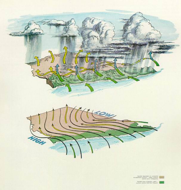
In winter, when the anticyclone paths move north, New South Wales is affected by westerly winds sweeping clockwise around the southern depressions. The impact of these winds is greatest in the southern parts of the State and least in the north. Often the westerlies have a southerly component with a long fetch over the southern ocean, so that they are cold and their lower layers are moist. Any uplifting of this moist air then causes clouds to form and often rain to fall. Uplift is provided by mountain ranges across the path of the wind and by the operation of frontal systems, and it is assisted by increasing instability in the airstreams as they move northward over a warmer land surface. Thus winter rains are fairly regular in the southern part of the State west of the Dividing Range. In the northern and western plains, however, instability showers are unreliable and most of the winter rain depends on the penetration of active cold fronts when the southern depressions move further north than usual.
The effect of air being made to rise as it crosses mountain ranges, called the orographic effect, is quite apparent in the winter rainfall situation. The western side of the Dividing Range receives relatively high rainfall in this season, but sheltered valleys immediately to its east which are traversed by the southwesterly air only after it has lost its moisture load, are rather dry. T hese are krown as rain shadow areas.
In the winter, westerly airstreams with strong southerly components can bring snowfalls to all parts of the Dividing Range even as far north as the Queensland border.
In summer, when the paths of the anticyclones move southwards, the rainfall regime is largely controlled by the easterly airflow to the north of the high pressure centres. The effect is most noticeable on the northern half of the coast and tablelands. At times, however, storms originating in the tropics or off the coast move southwards and affect the whole of the coast and tablelands and even parts of the inland.
The summer easterlies have long trajectories over the ocean before reaching the coast. Those which move in from north of east pass over warm ocean waters and tend to become more stable in their low layers as they move southwards over a cooler surface. Consequently they do not bring significant rains except when thunderstorms are embedded in the air mass, then heavy falls can be received in short periods.
On the other hand, those easterly airstreams which move in from south of east travel over cool waters and tend towards instability near the surface as they move northwards into increasingly warmer areas. These airstreams are responsible for the fairly regular and substantial summer rain received along the coast, particularly on the coastal ranges where orographic lifting assists the rain producing mechanism. Generally speaking, summer rain is heaviest where mountains close to the coast force the southeasterly stream to rise. It is least in deep valleys protected from the southeasterly streams by high ranges closer to the coast.
In the inland parts of the State major storms in summer are somewhat rare and the greater part of the rainfall is derived from the sporadic occurrence of convective thunderstorms.
In most of New South Wales the summer and winter are normally wetter than autumn and spring, but there are two main areas where this is not so. On the northern part of the coast and tablelands the wettest season is late summer and autumn, while it is driest in late winter and spring; and on the western slopes of the Southern Tablelands the wettest season extends through winter and spring, while the rest of the year is comparatively dry.
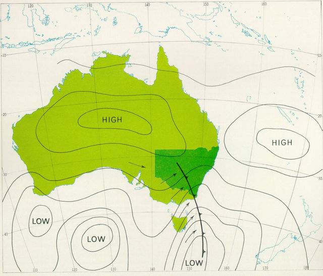 Synoptic Situation: Winter
In this situation anticyclones (or highs) move across the continent to the north of New South Wales. Winter winds are mainly westerly, often with southerly components which make them relatively cold and moist. Because of orographic effects along the southern coast of the continent and on the mountains, clouds and showers develop. Winter rainfall is fairly regular in the south and southwest of the State and on the western slopes of the tablelands; but in other areas it is less reliable.
 Winter Situation
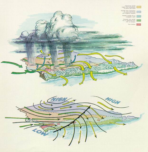
This figure illustrates the type of situation which produces much of the winter rainfall in New South Wales. Rather cold, moist southwesterly airstreams (green arrows) are made to rise on crossing the Dividing Range. This results in fairly regular winter rainfall in the southern parts of the State west of the Divide, while areas to the north and east have relatively low rainfall. On the northern and western plains, winter rainfall is largely dependent on cold fronts penetrating further north than usual.
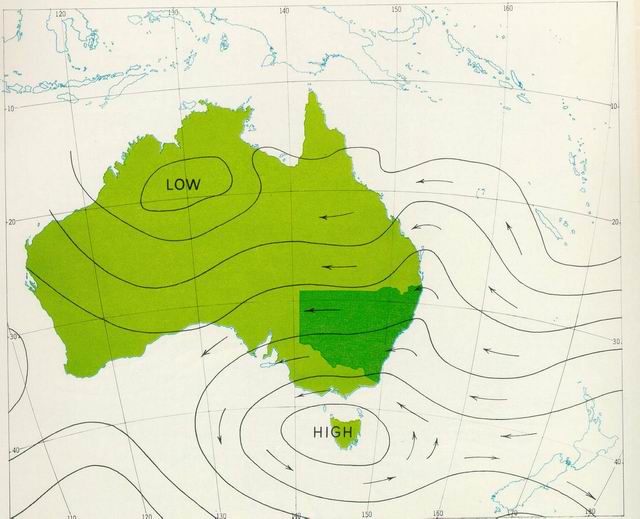 Synoptic Situation: Summer
In this situation, anticyclones centred south of the continent produce an easterly airstream over most of New South Wales. Rainfall is fairly regular on the coast and adjacent tablelands where the stream is moist. Further westward, the airstream becomes dry. Rainfall in these areas is caused mainly by convective thunderstorms associated with the development of troughs of low pressure in the stream.
 Summer Situation
This figure illustrates a typical situation which produces much of the surnnier rainfall over New South Wales Between the low pressure trough to the north of the State and the high pressure centre to its south, a humid easterly mrstrearn (green arrows) produces copious rainfall on the main ranges and to the east. As the stream continues westward it loses much of its moisture. With no orographic features to induce precipitation, the west of the State is largely dependent for its rainfall on convective thunderstorm activity.
Hydrology
We can use water without depleting its supply. But water is a fundamental component of a complex ecosystem - its maximum sustainable yield depends on how we exploit it within the system. Evidence of overexploitation and environmental stress is abundant. Pollution from human activities destroys aquatic life and threatens human health. Misuse of the water resource causes widespread degradation of soils, disrupts the supply of potable water, and generates massive economic losses. To be aware of the extent of these problems and to manage them, we need baseline data.
Being such a large state, NSW covers many different geographical regions. As a result, the hydrologic characteristics vary significantly across the state, and from north to south. Water and environmental issues are directly related to the hydrologic and socioeconomic conditions of each region. The management of those issues therefore requires an understanding of the regional hydrology. Measurements are the only reliable indicator of the status and trends of the available surface water.
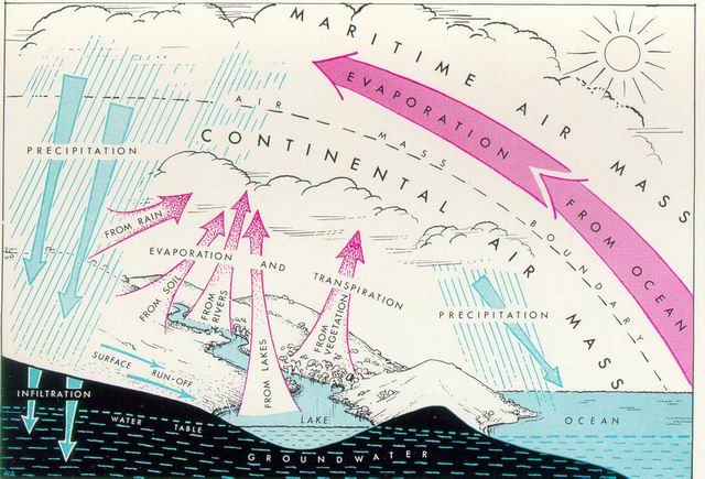
Water is the most abundant compound found on earth. Individual molecules of it are caught up in a vast and unending migratory system which transports them through different physical states, over long distances and to many places. These water transformation and transportation occur are known collectively as the "Hydrologic Cycle" or "Water Cycle". Within this cycle, a continuous circulation of water in all forms is maintained, with the amount of water in it remaining essentially constant. However, the distribution of water between the ocean, the atmosphere, and the land varies constantly. The most important agent in the cycle is the sun. It is the source of the energy required for the transformation of water from one form to another.
The cycle is continuous and it is convenient to describe it by considering it to commence at the oceans, where the largest amount of water is stored. Radiation from the sun provides the heat energy which causes evaporation from the ocean surface. The prevailing weather systems of the earth convey the moisture laden air masses over the continental land masses. As the water vapour is elevated to higher and colder levels it undergoes a cooling process and condenses into small water droplets. Particles of dust ever present in the air act as cells or nuclei around which the droplets form. As the droplets float in the atmosphere they tend to cluster together in groups, and appear as clouds or fog. The circulation of the air may carry the water mass to higher elevations causing further cooling and more and more condensation on each cell, until the water droplet is too heavy to be supported and it falls to earth as precipitation. This may be in solid form as hail, sleet or snow, or in liquid form as rain.
Part of the precipitated moisture is actually reevaporated during the fall to earth but by far the greater portion of it reaches the earth's surface. Part is intercepted before reaching the ground by buildings, trees and other objects, and some of this is reevaporated directly to the atmosphere.
That which reaches the ground follows one of three courses. It can be re evaporated, it can infiltrate the soil surface or it can move across the surface into stream channels.
Water Cycle
Of the portion that soaks into the ground, part is retained in pores of the soil close to the surface, and is either evaporated or consumed by root systems of plants to maintain and promote plant growth. This moisture finally returns to the atmosphere through pores in the plant leaves, by a process known as transpiration. The remaining water infiltrates deeper into the soil through various strata and either discharges into stream channels or becomes part of the groundwater storage held below the surface. From this groundwater storage enormous reserves of water can be tapped by sinking bores and wells.
The component of precipitation that flows across the ground surface and into stream channels is known as "surface runoff". Streams may also be fed by part of the infiltrated water which may be released slowly from temporary underground storage, maintaining surface flows for some time after surface runoff ceases. Collectively these two components of streamflow are referred to as runoff. Available quantities of runoff can be assessed, enabling the planning and development of water use systems involving, for example, dams, tunnels, pipelines and channels to serve man's needs for water.
No matter what path water follows through the cycle, it will eventually be returned to the oceans.
The runoff phase of the hydrologic cycle receives more attention than most other Phases of the water cycle for two important reasons. Firstly, runoff provides the major and most accessible source of water available to man. Secondly, it can be reasonably accurately measured because of its confinement in the channels of rivers and creeks. It is, in fact, a residual of rainfall which appears after the prior claims of several hydrologic processes are satisfied. Foremost amongst these are the requirements of infiltration, evaporation and transpiration.
Runoff does not occur until the rate of rainfall reaching the ground exceeds the rate of infiltration. The prevailing infiltration rate is influenced by the permeability and initial wetness of the soil, and by topography and vegetation cover. As a general rule, flat surfaces and dense vegetation cover are conditions which favour high infiltration for a particular soil type.
Evaporation takes its toll of both soil moisture and streamflow. Together with transpiration from plants and infiltration, it accounts for over 90 per cent of the average annual rainfall over New South Wales. The net amount of rainfall so absorbed, varies in different parts of the State. It is estimated to range from over 60 per cent of the annual rainfall along the coast to more than 96 per cent in the inland, reaching almost 100 per cent in the most arid regions.
The part of annual rainfall which finds its way into streams also varies widely throughout the State. Runoff ranges from over 1000 mm in some small coastal catchments to 600mm or so in the Snowy Mountains and is virtually nil in the extreme far west. Almost 70 per cent of the State's total annual runoff originates east of the Dividing Range and flows towards the Pacific Ocean. The marked transition in the amount of annual runoff across New South Wales is fairly closely related to the pattern of annual rainfall and evapotranspiration. Substantial volumes of runoff are carried by the large western rivers, but most of their flow is generated in their eastern headwaters, where rainfall is relatively high.
A study of the generalized pattern of average runoff in New South Wales indicated that significant differences in the amount of runoff occur from one valley to the next. Even minor variations in climate, topography and soils can produce significant changes in runoff. Such variations between adjacent valleys are particularly evident on the coast and in the tableland regions.
In the early days the primary focus for hydrographic discipline (the measurers of things hydrometric) was to gather surface water data to develop long term trends and get an understanding of the distribution of the resource throughout the state. The primary aim was to bolster the states water storage to support primary industry and provide reserves for both the expanding irrigation areas and town water supplies during dry times. Since the implementation of the Water Act 2000 more emphasis has been placed on more equitable sharing of both surface and groundwater resources requiring a change in philosophy from long term trends and assessment to the supply of real time and near real time streamflow knowledge. This requirement and the need to very accurately monitor low flow conditions has lead to a much more focused and intense monitoring of lower flow conditions in support of equitable sharing of the limited resource.
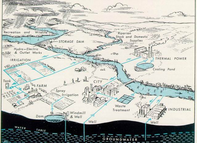
Whether for irrigation, town water supply, other human use, recreation, or habitat, there are many demands placed on this relatively scarce resource. In order to properly manage our water resources, we must have the means to measure them. Hydrographic stream gauging installations exist to measure the quantity and variability of our surface water resources. In addition, the analysis of streamflow data in combination with groundwater data helps us to understand the relationship s of the hydrological cycle. When flooding occurs, the hydrographic stream gauging installations are indispensable as tools for flood forecasting and warning along rivers and streams.
Measurement and recording of water level and for those stream installations converting the water levels to streamflow are still the core products or deliverables for the Hydrographic discipline. These processes involve measuring and recording water levels ranging from daily staff gauge readings, gas purge pressure and float well water level recording systems to analogue recording charts through to sophisticated electronic pressure sensors and computers (loggers) recording and transmitting the water levels from remote installations. DWE has the full range of these systems with the majority of the installations being managed by computers (loggers) and having telecommunications access to and from them. Other State agencies also operate similar surface water monitoring sites for other specific purposes.
For the majority of the networks the generation of the DWE network streamflow is a requirement. This is achieved by performing streamflow gaugings and developing a stage discharge relationship for each installation. The merger of this stage discharge relationship and the collected water level results in a time series set of streamflow characteristics for that location in the stream. Regular streamflow gaugings are required to confirm the calibration or recalibrate the stage discharge relationship of the specific installation.
The rivers in NSW are broken up into two groups for management purposes:
- Regulated rivers are those that are effected by the operation of storages (operated by State Water Corporation). The degree of regulation depends on the relative magnitudes of the storage and the yield of the catchment. In these regulated river systems the requirements of downstream licence and other entitlement holders are met by either downstream tributary inflows, downstream storages or headwater storages.
- Unregulated rivers in NSW are all those stream whose flows are essentially natural, ie the flows are not controlled by a major storage. These streams do include those where the flows are controlled by dams or weirs constructed by urban water suppliers or private users.